

The phrase “Ithaca is Gorges” now has a new, interactive meaning.
The City of Ithaca Geographic Information Systems Program has partnered with Google Maps to create a Google Street View of the off-street areas of Ithaca, which was unveiled the morning of Nov. 19.
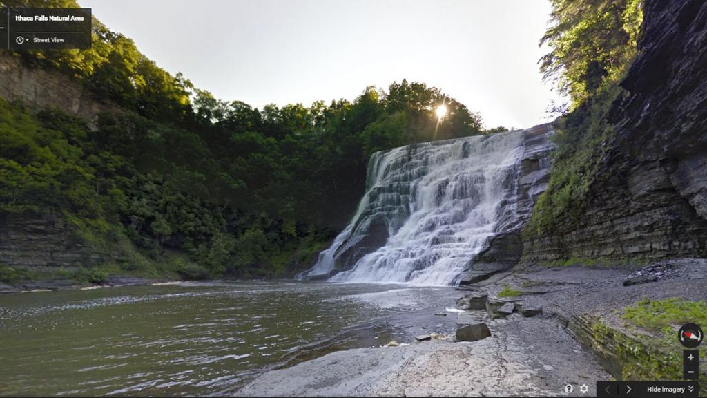
The 360-degree view of Ithaca’s natural areas allows Google Maps viewers to take a virtual tour through places that cannot always be easily accessed, such as the Fall Creek Gorge, Cayuga Waterfront Trail and the Ithaca College Natural Lands.
The GIS Program team consisted of staff members Susan Nixson and Chris Morrissey, who were aided by volunteers Marilyn Dispensa, instructional technology coordinator at Ithaca College, and Zeb Strickland, gardener at the Cornell Plantations. At the demonstration of the navigational tool on the second floor of City Hall in Ithaca, Nixson said the technology allows visitors and residents an intimate view of places they might not be able to reach due to physical inability or the weather, and it offers students a unique opportunity for study.
“When you look at the educational opportunities that this provides, this really gives an opportunity for virtual fieldwork because the resolution for this imagery is fantastic,” she said.
Areas that can be viewed interactively with Street View are highlighted in blue on Google Maps, as Nixson showed in the demonstration.
After just half a day of training on July 15 with the backpacks from a professional Google tracker, she and her team prepared to hike as many trails as possible under the most ideal conditions: bright but cloudy. They backpacked through the natural areas throughout the months of July and August, carrying 40-pound backpacks with 15 cameras that take photos from all angles every 2.5 seconds, Nixson said. This way, the cameras capture a full circle of imagery to then send to the Google satellite.
Nixson, who also lectures at the college, said she applied for the opportunity to obtain a Google Street View through the Trekker Loan Program in the spring after viewing a blog announcing the virtual documentation of the Grand Canyon.
“Really it was just a random proposal, a couple of sentences I sent to Google, and they jumped right on it,” she said.
Nixson said the project was free of charge for the GIS team, which also received a $500 stipend from Google that covered its transportation costs.
Kristy Mitchell, integrated marketing manager at the Ithaca and Tompkins County Convention and Visitors Bureau, said she is excited about the implications of this technology for tourism.
She said she knew the team was tracking the state parks, but was not aware of the extent to which it was working with Google. The tool has the potential to be an attractive feature for the area, she said, but the bureau does not yet have concrete plans for advertising it.
“I don’t know what yet because this is our first sneak preview, but I’m sure we’ll plan on integrating it into our website because it’s a really cool thing,” she said.
Ruth Aslanis, GIS program manager, said in addition to promoting visitors, the Street View can be a useful tool for emergency response. For example, it maps the gorges and their steep spots, which can allow emergency teams to better determine how many responders should safely transport people to and from specific locations.
“The work really begins now that the imagery exists,” she said.
It wasn’t until the imagery existed in full that Nixson’s team was able to go public with any of its work. The release was held until 10 a.m. Nov. 19, when Google completed translating the images, which was part of the no-publicity clause Nixson said she entered into from the beginning.
The launch of the completed project coincided with GIS Day which, as per tradition, lands in the middle of Geography Awareness Week, Aslanis said.
Susan Cadrecha, a spokesperson from the Google Trekker program, said Google Maps Street View is available in more than 63 countries across seven continents, including much of the United States.
“Working with the City of Ithaca Geographic Information System Program through the Trekker Loan Program has allowed us to add this first-ever beautiful imagery to Google Maps for more than 2 billion users around the world to explore and enjoy,” she said.