
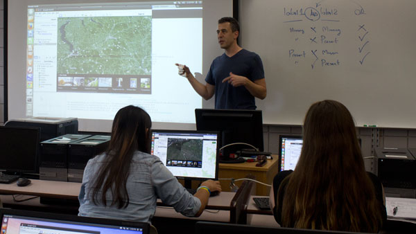
This semester, Ali Erkan, associate professor in the Department of Computer Science, is bringing together students and faculty to learn about digital mapping in his 100-level course, Geographic Information Systems.
GIS technology is valuable across many disciplines, as is reflected in the diversity of the class. The 20 students in the course span a range of class years and majors, including environmental studies, journalism, anthropology and computer science, among others. There are also five faculty members enrolled in the course.
Erkan, who is teaching GIS for a third semester, said the course objectives are to teach those enrolled how to create digital maps, use computer-based problem solving and analyze correlations between different types of data.
“These are maps that you could put on top of each other, and each might be a different kind of information,” Erkan said. “You might have one map that shows land ownership, you might have another map that represents voter districts, you might have another map that represents maybe income levels.”
Junior Corinne Weinstein, a television-radio major, said the class was hands-on from day one.
“The first day we used Google Maps and Google Earth,” she said. “[Erkan] has information open for discussion, and then you can comment if you want, and then also, assignments get handed in on Google Docs.”
The class will also teach students how to use Linux, a computer operating system. Erkan said he’s introducing Linux because it’s free, effective and has fewer glitches than other systems.
Despite the fact that his class revolves heavily around computers, Erkan said this course is open to anyone who is interested.
“It’s an introductory class, which assumes nothing,” Erkan said. “There are no expertise expectations; you do not need to know how to program computers.”
However, he said the learning curve could be a little steep because of the fast-paced nature of the class. According to the syllabus, hands-on learning is an important aspect, and from the beginning, students and professors enrolled in this class will be spending a majority of their time working directly with computers.
Erkan said his ultimate goal for this class is to create better thinkers and better problem solvers.
“What we hope to get at the end [is] to produce individuals who are competent in this technology, so they can be better at whatever they want to do,” he said.
Sophomore Mariah Flaim, a journalism major, said she is planning on using this class to better her journalism skills.
“Ali came into my journalism class and said that GIS is … a good thing for journalists to have as a skill because you would be able to tell a story with a visual and … you could do it yourself, so you [have] that extra skill to get you ahead,” Flaim said.
Using and manipulating data in journalism has gained growing importance in the field. According to The Guardian, “being a data journalist is no longer unusual. It’s just journalism.”
Senior Cory Wydysh, a physics major, was inspired to take this course after working with a professor on an archaeological research project, because he believes that GIS technology would be useful to similar pursuits. Wydysh said he would encourage the professor he worked with to take this course.
Meanwhile, Erkan said he is learning alongside his students as he continues to teach this class.
“You have different disciplines, you have journalists sitting next to anthropologists sitting next to environmental studies,” Erkan said. “So how do you teach technology in an appealing way to all three in the same lecture?”
An internal grant from the Provost’s Office is funding four of the five professors to take GIS. The professors are from the departments of history, anthropology, economics, strategic communication and politics. Ali said professors enroll in the class to enhance their respective fields of study and to bring back the knowledge to their courses.
Flaim said having professors as classmates is an interesting aspect of the class.
“It’s awesome that there are teachers in there learning with us, because it shows that even adults and professors don’t know exactly what you’re learning at all times,” she said.
Erkan said he looks forward to seeing what GIS can do for his students and their respective fields, and he has aspirations of incorporating the technology into student media at the college.
“The purpose of the course wasn’t to produce more computer scientists, it’s making technology more easily usable by people who need it,” Erkan said.